
‘The insurance companies cannot be too well informed where thousands of pounds may hang on a tiny window in a party wall, or in other “trifles,” and which in many instances they are ignorant of.’ (Herald, 23 Dec 1925)
Starting in the late nineteenth century, Melbourne insurance companies would consult a detailed set of city plans to assess the fire risk of a building, before granting insurance to their clients. These plans were produced by Mahlstedt and Gee (later just Mahlstedt’s), a company of fire engineers and surveyors established in 1884.

Mahlstedt’s created these plans for the Insurance Planning Association. The plans contain detailed information about the form and construction of buildings in Melbourne and other cities in Australia. State Library Victoria holds plans from 1888 through to 1962, covering not just Melbourne but also Geelong, Ballarat, Bendigo, and other cities across Australia.
The earliest set of Melbourne plans, from 1888, features basic details – usually the name of the building or business, a footprint and an indication of the building material. Later plans became increasingly more detailed, showing internal features, such as the layout of rooms, and the location of lifts and staircases. Prior to the existence of these plans, insurers would look only at a building in isolation. But it was found that it was more effective to survey not just the building, but the “block risk” or “contiguous connecting risk”. As The Herald newspaper so eloquently put it, this would allow them to scrutinise “the loopholes and by-ways by which the “fire fiend” leaps from afar and swallows up most unlikely prey.” (Herald, 23 Dec 1925)
These plans can be incredibly useful for tracing the history of a block of land. Because the Library holds plans spanning 1888 to 1962, it is possible to track the appearance of new buildings, see renovations or alterations, different tenants and demolitions. The section of Bourke Street between Swanston and Russell, for example, was once the location of a thriving group of theatres. The plans below show this area, which was home to The Tivoli Theatre, Paramount Theatre, The Gaiety Theatre and The Bijou. A later plan, from the 1960s, reveals that all four theatres are gone – the Bijou has been demolished and become a Commonwealth Bank, and the Tivoli a mixed use building. The slider can be dragged back and forth to compare the changes to this city block.
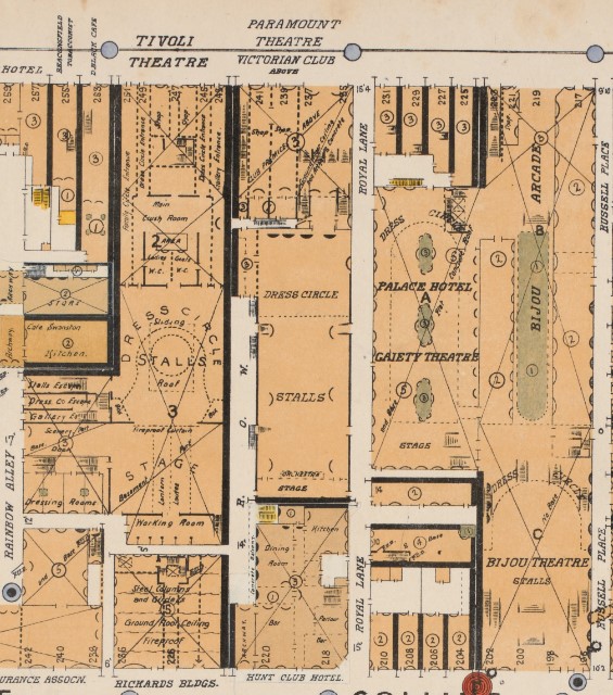
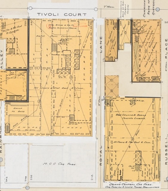
City of Melbourne detail fire survey. Section 1. Version 1. [map 8], 1925? Cartographic material by G. Mahlstedt, Mahlstedt, Melbourne; Melbourne plans. Section 1. Version 1. [map 8], 1948. Cartographic material by G. Mahlstedt, Mahlstedt, Melbourne. *Note that the 1948 plans have been altered later in the 1960s as the Tivoli Theatre was not demolished until 1969
The plans were living documents, and between editions, changes to buildings were recorded by pasting overlays onto the original maps. In some cases State Library Victoria holds several copies of the same volume each containing slightly different overlays illustrating changes to the cityscape. Below we can see updates to a 1923 set of plans showing the construction of William Angliss Food Trades School, which was built on the site of the West Melbourne Boys’ Technical School, in Latrobe Street.
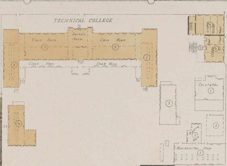
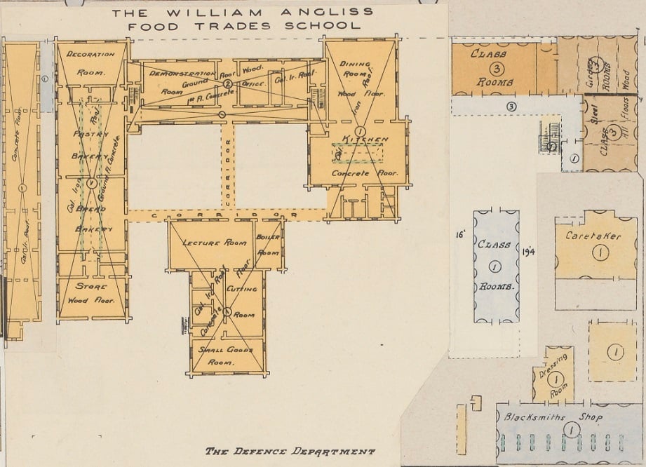
City of Melbourne plans. Section 2. Version 1. [map 1a], 1923-1928. Cartographic material by G. Mahlstedt, Mahlstedt, Melbourne; City of Melbourne plans. Section 2. Version 4. [map 1a], 1923-1928. Cartographic material by G. Mahlstedt, Mahlstedt, Melbourne
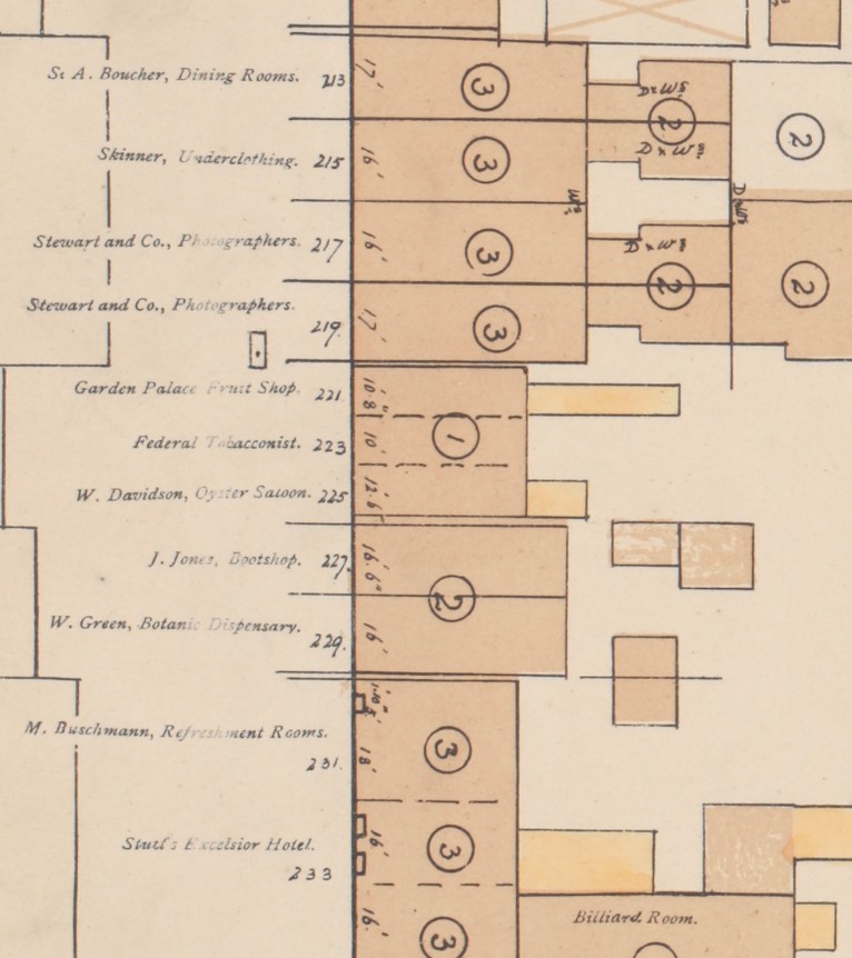
Because the names of businesses were listed, the plans give a strong sense of Melbourne’s streetscape at certain periods of time. It’s quite evocative to look at a well known part of the city from a time in the past and imagine life on these streets. The map below shows the eastern end of Bourke Street in 1888, and reveals several types of businesses we no longer see, including a tobacconist, botanic dispensary, and oyster saloon.
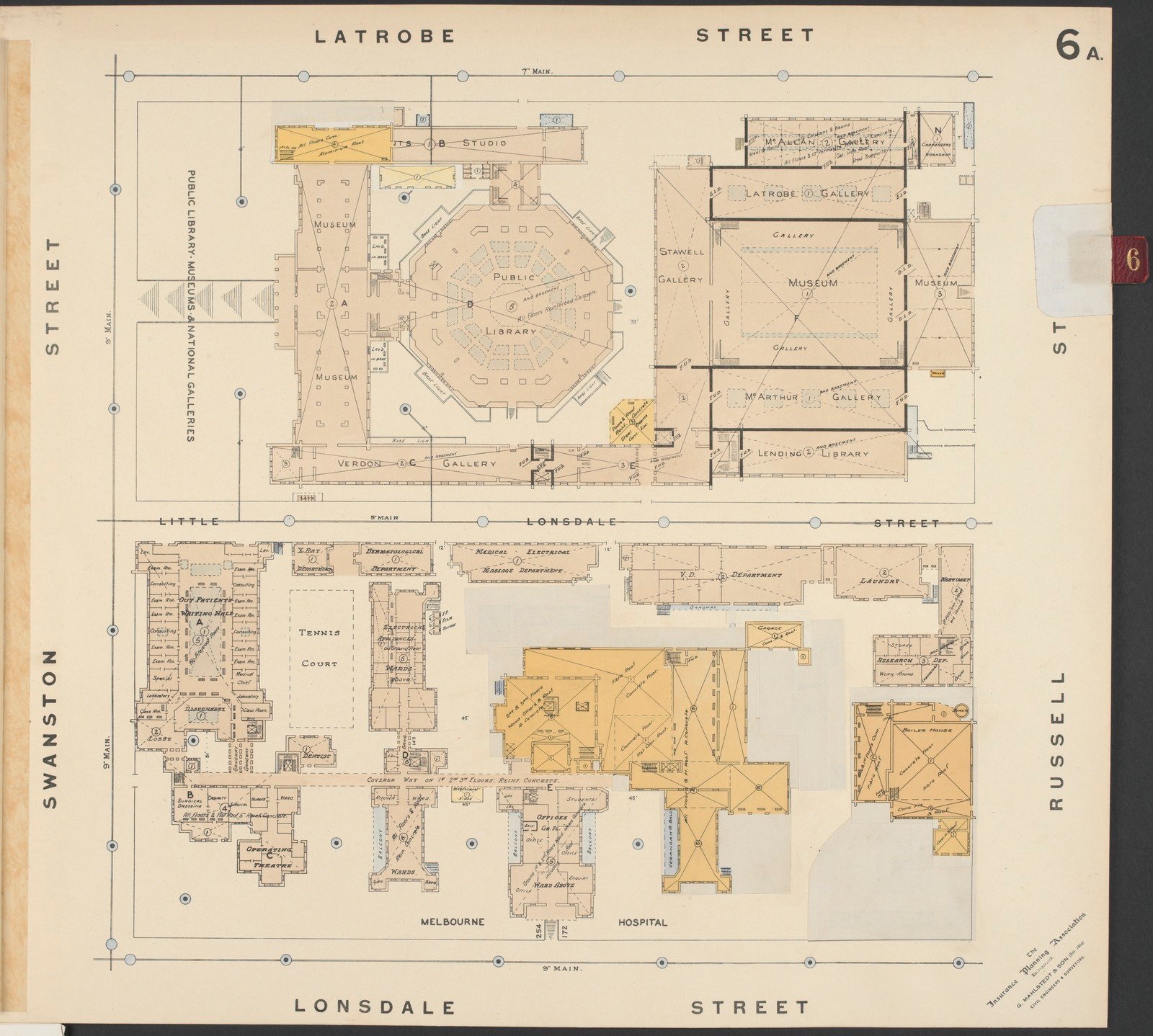
The Mahlstedt plans feature an incredible level of detail about the interior of buildings, and allow us to see where a building has been altered or remodeled in some way. Where architectural plans do not exist, they are a boon for researchers looking at the architectural history of a site. The Melbourne Town Hall, for example, was damaged by a fire in 1925. Following the fire, a “larger auditorium was built which extended the footprint of the Town Hall across the site of the former Victoria Coffee Palace”. 1 The plans below, from 1910 and 1948, show the changes between the original layout, and the new one with a rebuilt, extended auditorium.
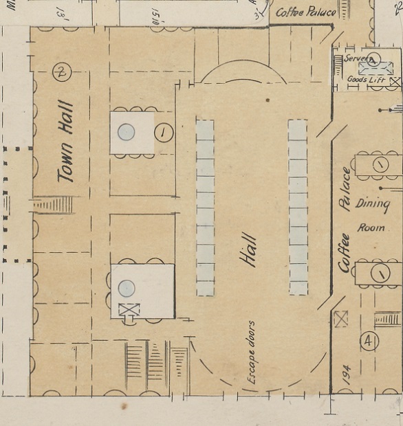
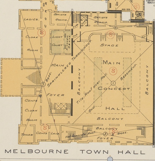
Index to City of Melbourne detail fire survey, [map 8], 1910. Cartographic material by G. Mahlstedt, Mahlstedt, Melbourne; Melbourne plans. Section 1. Version 1. [map 8], 1948. Cartographic material by G. Mahlstedt, Mahlstedt, Melbourne
State Library Victoria’s copies of the Mahlstedt plans have all been digitised and can be viewed via the catalogue.
- Tucker, G, 2008, Melbourne Town Hall, eMelbourne, School of Historical & Philosophical Studies, The University of Melbourne, viewed 15 September 2021, https://www.emelbourne.net.au/biogs/EM00956b.htm