
Former creative fellow and author, Dr David Sornig, shows us how the library’s maps and manuscripts chart the demise of West Melbourne’s wetlands in his special guest blog this week.
The 8 square kilometre zone to the immediate west of Melbourne’s CBD is today dominated by its industrial, transport and urban uses: from the Docklands redevelopment through to the Bolte Bridge, Appleton and Swanson Dock, the network of freight rail yards and the recently-vacated wholesale markets.
But for thousands of years the area was part of a fertile wetland whose most striking features were the meandering north-west course of the Yarra River and a large blue saltwater lagoon.
The story of the area’s radical transformation over the 181 years since Melbourne was founded – and perhaps why it has never quite found a comfortable place in the public imagination of the city – is revealed through the library’s collections of maps and manuscripts.
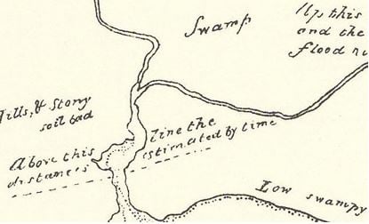
Detail from map of Port Phillip surveyed by C. Grimes in 1803
The earliest European references to the area are found in documents from Charles Grimes’ 1803 survey. Grimes’ map simply refers to the area as ‘Swamp,’ while James Flemming, a member of Grimes’ party, writes of having seen from the intersection of the Maribyrnong and Yarra rivers ‘a large lagoon at a distance.’[1]
John Batman’s account of his own party’s 1835 venture through the area refers to crossing ‘on the Banks of the River a large marsh about 1 ½ mile by 3 or 4 long’ on which he saw ‘1,000 quails, flying at one time quite a cloud.’ He noted also that ‘[a]t the upper end of this marsh is a large lagoon. I should think from the distance I saw that it was upwards of a mile across, and full of swans, ducks, geese, &c.’
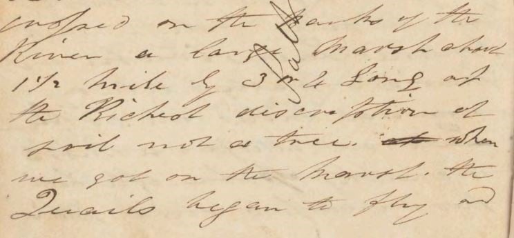
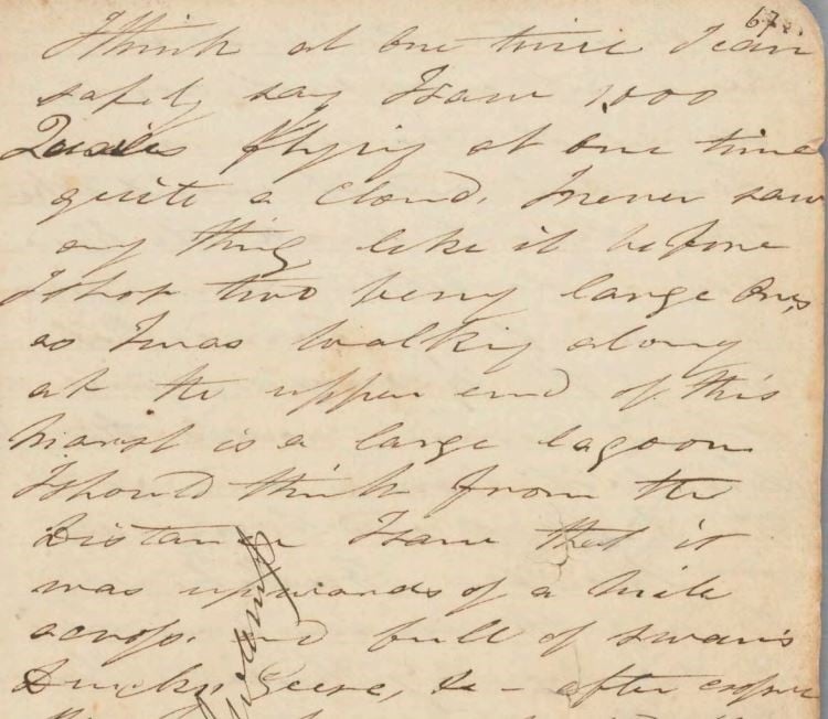
Excerpt from John Batman’s Journal, 10 May-11 June 1835, pp 66-67
While Melbourne grew rapidly in Batman’s wake to become an important centre of finance and trade, the lower reaches of the Yarra and the lagoon came to be viewed as a barrier to progress. A difficult-to-navigate stretch of the river was known as Humbug Reach, notorious for becalming – or ‘humbugging’ – trading and passenger ships, sometimes for days at a time. The lagoon, which was referred to variously as Batman’s, West Melbourne or North Melbourne Swamp, was ringed by slaughterhouses and boiling-down works that took on the job of reducing the colony’s near endless stream of slaughtered sheep and cattle.
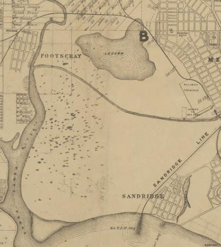
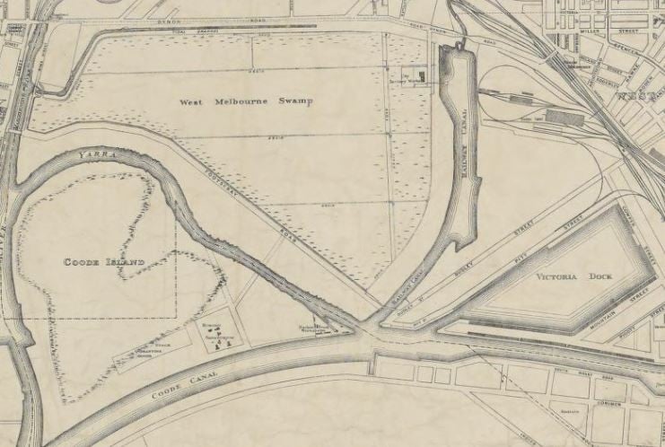
Detail from Victorian Railways, Melbourne & Suburbs map by the Railway Department, 1873
By 1873, the Victorian Government’s Royal Commission on Low Lying Lands [2] had recommended doing away with the ‘repulsive aspect’ of the area, including the swamp, through a program of drainage, reclamation and improvement. And by the end of the decade, the Melbourne Harbour Trust had Sir John Coode draw up plans to divert the difficult-to-navigate course of the lower Yarra into a wide, deep canal along a direct course from the city to the river’s mouth.
Coode also set in train the dredging out of the eastern end of the zone to form the city’s main harbour – Victoria Dock. Together, the canal and the old course of the river formed Coode Island and became home to the Bubonic Plague Sanatorium and the Animal Quarantine Station. A second canal was dredged to the north for the delivery of coal to the rail yards and beside it was built the sanitary works, which were intended to deal with the vast volumes of night soil from the city’s still-unsewered streets. Scattered through the area were any number of official and unofficial rubbish tips that were used by the surrounding municipalities, the Victorian Railways, the Melbourne Harbour Trust and private citizens.
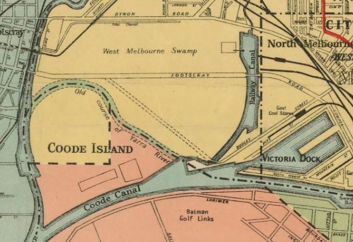
Detail from Melbourne and suburbs map by Department of Lands and Survey, 1910
Given its isolation, and the opportunities it presented for picking the tips, the area came to attract through first decades of the twentieth century a scattered number of hermits and itinerants who made homes out of scrap. By the early 1930s, when the Great Depression put thousands of people out of work, a full-blown shanty town grew up either side of the Railway Coal Canal. Known as Dudley Flats, it served for the best part of a decade as a place of refuge and subsistence living for as many as a sixty people at a time.
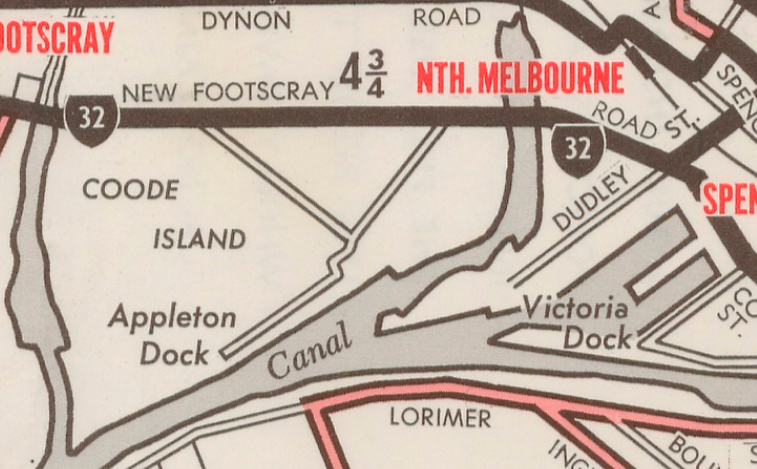
Detail from Melbourne and suburbs map by Department of Lands and Survey, 1935
By the middle of the century the Dudley Flats settlement had largely ceased to exist, with only a few men sticking to their lives on the tips. Barely any trace remained either of the silted-up original course of the Yarra as the docks and railway yards encroached further into the area. Through the 1950s and ‘60s the tips were closed, the wholesale markets were built on the north side of the new Footscray Road, and an enormous slice of Coode Island was carved away with construction of Swanson Dock. By the 1970s any last trace of the wetlands, the lagoon and original course of the river disappeared from the maps completely.
Map of Melbourne’s tram & bus routes and time-table of first and last, Sunday and all night services by the Melbourne and Metropolitan Tramways Board (MMTB) 1967
Read more about Melbourne’s wetlands in David’s book Blue Lake: finding Dudley Flats and the West Melbourne swamp
References
[1] Flemming, J., Knopwood, R., & Shillinglaw, J. J., 1873, Port Phillip, first survey and settlement of, John Ferres, Government Printer, Melbourne
[2] Victorian Low Lands Commission, 1873, Low Lands Commission: progress report, John Ferres, Government Printer, Melbourne
Thank you!!
Very interesting read
That’s great Sarah. Really enjoyed it. I just went to a lecture yesterday at RHSV by Dr Gary Presland on the Natural History of Melbourne which was about this kind of info but he didn’t mention this area so it’s a bonus! I used to work at SLV as a Librarian must follow this blog. Cheers
Pleasure in the further understanding of the natural state of this Wetlands area of Melbourne, and the subsequent changes wrought since settlement in its water/land relationship as it continues to provide support and service to its inhabitants
(Further to the above Comment).
Childhood impressions (from 1950s) of the lower reaches of the Yarra River, the Melbourne wharves, the flat land around Dynan Rd which comprised the old tip area (once announced by the sea gulls ever circling above), the old car punt crossing to the Western suburbs, and even the more recent views ‘snatched’ whilst driving across the West Gate Bridge, have all been like separate parts of a jig-saw puzzle I could never put together in my mind as an integrated landscape – until today – when I read David Sornig’s paper and studied the associated maps and documents held within in the SLV Maps and Manuscripts Collections. The resolution of ‘one of life’s mysteries’ affords me both satisfaction and I suppose ‘closure’, now that the once ‘unknown’, becomes the ‘known’. I am left wondering though, why I never resorted to the Melways or a fold-out tourist map of Melbourne’s west, which might have contributed sooner to a more integrated understanding of that flat and puzzling landscape, so transformed from its natural state, by the intervention of industrialized man.
Anne, your comments have much resonance. My father was a shipping agent, and had a bond store in the area off Footscray Road in the 60s and 70s. Even spending lots of time down there, it was difficult to figure out exactly the context of this area in terms of broader Melbourne. The area always fascinated me, and on the weekends when we often visited, it always had an eerie and desolate quality. I enjoyed reading you impressions.
My unknown chartered territories involve the no-man’s land between the City of Melbourne and where the Williamstown Ferry once docked? I feel certain it’s now well-settled and become an industrial city but – like Ann Brothers my vague impressions from the early 1950s tend to need filling in a bit more. For example a visit to the RBG elicited the advice that a vagabond homeless sort of criminal named James Mannix. This rings bells with me given the existence of scandal prone Archbishop Mannix in the era of WWI conscription votes? Were there known homeless vagabonds known to inhabit Dudley’s Flats and/or the no-man’s land between where the Ferry docked and the inner city of Melbourne???
Provides a fuller understanding of the natural state of the landscape, and changes brought about since settlement in its provision of resources and services for its inhabitants.
You may be interested in this article of mine just published in the Victorian Historical Journal:
https://www.academia.edu/26422124/Lost_and_Found_Wetlands_of_Melbourne
Thanks for making this information more widely known; I have been interested in the subject of wetlands for a while, more particularly in the ways in which wetlands have been seen at different times, and within different social contexts. I’m intending one day to write a major study on Melbourne’s vanished wetlands. I’ve been gthering material and thinking about it for a while. So far all I have published is a brief article in The Victorian Naturalist, vol. 131, pages 96-105, 2014.
Some more info on Melbourne’s Wetlands can be found here: http://members.ozemail.com.au/~garyhelen/indwet1.html
and on Dudley Flats, here: https://www.academia.edu/1968555/Dudley_Flats_Archaeological_Investigation
And some pictures and maps of both here: http://www.hothamhistory.org.au/documents/Gary-Vines-West-Melbourne-Batman%E2%80%99s-Swamp.pdf
I remember getting the fright of my life when, as a 14 or 15 year old, digging bottles at Dudley and we came a poor homeless guy who had set up a shanty in about 1974 or 1975.
He wasn’t there for long, but would have been more of an isolated case rather than the pandemic as discussed in the article.
Pingback: The place for a park? – Port Places
Did the spoil from the river and docks go to filling and raising the level Elwood?
Hi Bruce, thank you for your comment. I’ll lodge your enquiry with our Ask a Librarian service and someone will be in touch with a response.
Regards
Paul
change of consciousness and environmental actions always accompanied by stark acoustic changes, a barometer of habitat change. Dr Ros Bandt
How am I just learning about this fascinating, and sad, history of Melbourne now?! I won’t look at this ugly side of Melbourne the same again. Wish I could do the walking tour that was going a few years ago with David Sornig. In my mind, I’m trying to overlay what was, with what is today.